Friday, 6 May 2011

Day 6 - MOAB - Ben, Caiti and Nick

DAY 6 - Arches National Park, Moab, UTAH
Ben Walton, Nick Henderson & Caiti Walter


Today we visited the Arches National Park, which is located in the South-West USA in the state of Utah, 5 miles north of Moab (National Park Service, 2010). Our visit covered the southern and eastern regions of the park. We entered the park at 8.40am, where we were all distributed official National Park Service information booklets and maps of the park upon entry. We first stopped at the “Visitor Center”; a subtly designed building in keeping with the surrounding environment, with the paintwork a similar colour scheme to the natural rocks, so as not to create an eye sore. This is located at the south tip of the Park, as shown in Figure 1.

Figure 1 - Map of Arches National Park near Moab, Utah
Ref: http://www.her-motorcycle.com/images/arches.gif

Once inside the Visitor Center we watched an educational video to give us an insight to the park. The group found the video useful and informative and encouraged us all to explore further.
We then drove on the only tarmac road into the park, where we were able to gain our first impressions of the overwhelming scenery. We were struck by the sheer size of the park, the abundance of stunning natural features and the impressive geology present.

The first site we visited was the Windows Section, followed by a 3 mile-round hike to Delicate Arch from the car parking area. Figure 2 shows a photo of the Windows Section, where the North and South windows are evident. It is important to note the scale of the features shown; the two windows are estimated to be 100m apart. The Windows Trail is 1.1 miles in length.

Figure 2 - "North and South Windows" at Arches National Park near Moab, Utah
Ref: Personal Photo

Then we visited Delicate Arch, a 118ft tall archway located at the end of a 1.5 mile trail to an elevation of 5,300ft, shown in Figure 3. We were surprised by the number of people who were at and around the arch when we arrived. We had mixed views and opinions of Delicate Arch; some members of the group expected the arch to be much taller, whereas others thought it was better than expected.

Figure 3 - "Delicate Arch" at Arches National Park near Moab, Utah
Ref: Greg Spellman.

Whilst in the National Park, one thing that became apparent was the lack of tourist information around the trails. This meant that tourists could not learn about what they were seeing whilst trekking the trails; the majority of information could only be found in the Visitor Center. The facts below were gathered in the Visitor Center at the end of the day; while this was a disadvantage because tourists were unable to learn on the move, the lack of signs meant that the landscape remains unspoilt, which we believe to be a deliberate management technique.


Listed below are some bullet points that we noted within the National Park and at the Visitor's Centre as showing evidence for and information about Tourism, Physical Geography and Resource Management. Our notes have been divided into these three categories.


Tourism

  • Between 1955 and 1975 visitations of the park increased 550%. This was because in the 1950's a project called Mission G6 intended to meet tourists needs better.
  • There were lots of tourist information boards in the Visitor Centre as well as at the start of the trail.
  • There were directions to each attraction on the trail.
  • Signs warning tourists about dehydration, wearing correct footwear, dangers of wildlife, etc. were evident.
  • The rock climbing opportunities make it an ideal destination for tourists looking for adventure.
  • Signs reading no pets and no bikes on the trails limits who can go there.
Ref: National Park Service (2011)


Physical Geography

  • Within the park are petrified dunes and much of the south-eastern part of the park is exposed Navajo sandstone.
  • This sandstone was deposited approximately 175 million years ago when the desert was covered with much of what is now Western USA.
  • One feature within the park is Balanced Rock, which stands at 128ft tall. It takes the shape of a large solid ball made of slick rock (a member of the Entrada Sandstone) and appears to be balancing on the top of a column of Dewey Bridge. Eventually the base will erode and the rock will fall.
  • The Windows Arches, including Double Arch, were formed at the contact between the underlying and crumbling Dewey Bridge and the solid slick rock sandstone layers.
  • The trail to Delicate Arch is on the side of a collapsed salt dome where layers are turned or jumbled as large blocks of landscape drop unevenly.
  • The rock developed from 5000ft of salt accumulating. The seaway evaporated and refilled 29 times. Mountains eroded debris, which washed into the basin. Pressure on the salt forced salt into the area. 
  • Cracks at the edge of the Salt Valley widened and thin walls of sandstone (or fins) formed behind. Many arches formed from fins.
  • 3 miles wide and 70 miles long was buried with 1 mile of sediment, which turned to rock. Regional uplift of the overlying rock caused the rock to wrinkle on the surface, creating long parallel cracks. The rock was eroded 1 mile. The cracks in the surface allowed water in which dissolved the salt below. There was no support, causing the rocks to collapse leaving todays Salt Valley.
  • This process happened over the space of 310 million years.
  • Water is not abundant here and changes the landscape suddenly but forcibly.

Ref: National Park Service (2011)


Resource Management

  • Evidence of management of the park is shown by:- 
  • The tarmac road leading into the park,
  • Limited car parking, 
  • No access to Delicate Arch except on foot, 
  • Educational information for tourists to reduce their impact, 
  • Limited signs and therefore limited impact on the landscape, 
  • Recycling and rubbish collection with "trash cans", "plastic" and "aluminium" bins to promote sustainable living
  • Fencing and signs made from wooden timber, rather than manufactured metals.
  • "Trail Rules" are in place to minimise impact
  • A sign on the Delicate Arch trail reading "Project funded by this parks user fee", informing visitors how their money is being spent, ie. on the trail improvement project.
  • By have minimal impact in terms of real management they are preserving the parks natural state as much as possible.

Ref: National Park Service (2011)


References
National Park Service (2011) Visitors Centre Information. Department of the Interior; Moab.
National Park Service (2010) Arches National Park U.S. Department of the Interior; Moab. Issue 3. 8.

Day 5 - Navajo Reservation - Elliott, Ash and Jen

Day 5 – Navajo Reservation
Date - 4th May, 2011

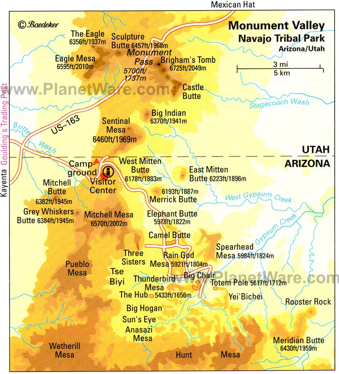
Figure 1: Map of Navajo Reservation: PlanetWare (2011)

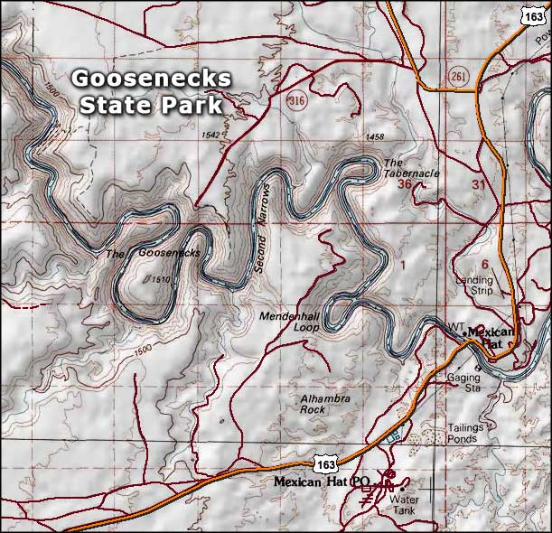
Figure 2: Map of Gooseneck State Park: VNizzle (N.D.)

Description of Locations

The first place we visited was Monument Valley (Figure 1; Figure 3). This is located beside the state line of Arizona and Utah on the Colorado Plateau and has an elevation of 5,564 feet above sea level. The area is characterised by several sandstone buttes, mesas and plateaus that are between 400 and 1000 feet in height (Navajo Nation Parks and recreation, 2011).

Figure 3: View from Visitor Centre: Monument Valley (Personal Photo)

Figure 4 shows John Waynes cabin at Gouldings Lodge. This area offers tourists the opportunity to experience a film set for a Western and to explore some of John Waynes equipment used within his films. Adding to this, there is a memorial for John Wayne outside of the cabin.

Figure 4: Ash entering John Wayne's Cabin (Personal Photo)

Figure 2 represents the last place visited, Gooseneck State Park, located 4 miles off Utah highway. Gooseneck is characterised by a meander in the San Juan River. It offers outstanding sights of natural processes that have occurred. The river can be seen to have cut 1000 feet deep into the Pennsylvanian Hermosa Formation (Utah.com,2011), that was laid down between 286 and 320mya (McGraw, N.D).

Figure 5: View of Gooseneck State Park, provides fantastic scenery for tourists visiting the park (Personal Photo).

Tourism


Figure 6: The directors chair is one of many features at Golding's Lodge of the western movie history


 In 1958 the Navajo reservation government consulted dying residents about making a park at Monument Valley (Figure 1). Some residents were not in favour of the plans, however many residents were extremely pleased with the idea due to the number of positive impacts, such as increase in employment due to the surge of tourism demand. With the park now built the original visitor centre opened in 1960 and because of this the area was supplied with electricity and water hauled in by truck to fill a storage tank. Adding to this, further facilities such as power lines, phone lines and fresh local water began to be spring up in the area. Today many residents support themselves by selling arts and crafts and provide many other services to tourists. Finally, Monument Valley is not a national park which gives tourists a more hands on experience of the attraction.

 Another source of tourism is the western history of Golding’s lodge. Many films have been produced within the area making it extremely popular for tourists. There are a vast range of tourist facilities available, these include museum, restrooms, car parks (disabled parking), seating areas, a gift shop and John Wayne’s cabin which allows the tourist to experience what Westerns were like in great detail.
Finally, Gooseneck is a primary tourist attraction, which attracts many tourists every year. Facilities here include toilets, information boards, a picnic bench and spacious car parking which gives the tourist the essential facilities to enjoy the attraction more appropriately.

As the observation show, there are many more facilities at Monument Valley compared to Gooseneck (Figure 2). This might be because people are more aware of Monument Valley, resulting in a higher tourist demand and therefore more facilities. During our visit, it appeared  that there were fewer tourists in the visitor centre than at other National Parks we had visited, such as the Grand Canyon.. This may explain why the number of tourist facilities was also lower than other National Parks we had visited so far.

Resource Management


Figure 7: Car park beside Golding's Lodge in a relatively unmanaged area despite tourist demand


The Diné people, the original settlers of Monument Valley used the land to sustain themselves as a population. They planted crops and used irrigated the land by using water trapped in a natural dam. The land however was poor for agriculture and larger areas were required for the Diné people to carry out effective subsistence farming. Since the mid 1800s, the Navajo have been the primary settlers on the land and  reared livestock along with some crop farming. This continued until 1920 when the fossil fuels of oil, gas and coal were beginning to be extracted from the area and used as an economic resource. In 1942 and 1943, World War II caused a rise in demand in uranium, a source of which was known to be within the area. This resource, along with the extraction of fossil fuels, provided the local Navajo population with jobs and a ‘modest’ income. However, despite the extraction of uranium ending in the late 1960s, the workers still suffer from the waste from the uranium, some of whom used local dirt as mortar for their dwellings, without knowing it was contaminated.

 In the current day, the area still holds economic benefits in mineral extraction; although an added benefit of tourism has further raised the financial gain from the area. The popularity of Monument Valley in westerns has sourced popularity of the area and the scenic views.

The area has had recent development in facilities to compensate for the number of tourists including a hotel named ‘The View Hotel’, visitor centre, bar and gift shop, all in one location. Although Monument Valley holds ‘value’ both economically and scientifically, the area is not listed as a national park. The reason is because it lies within the Navajo territory and , due to the Navajo’s lack of financial resources, the extent and number of which facilities are available does not match that of other national parks, such as the Grand Canyon.


In 1958 the Navajo reservation government consulted Diné residents about making a park at Monument Valley. Some residents were not in favour of the plans, however many residents were extremely pleased with the idea due to the number of positive impacts it brings to area, such as increase in employment due to the surge of tourism demand. With the park now built the original visitor centre opened in 1960 and because of this the area was supplied with electricity and water hauled in by truck to fill a storage tank. Adding to this, further facilities such as power lines, phone lines and fresh local water began to be spring up in the area. Today many residents support themselves by selling arts and crafts and provide many other services to tourists. Finally, Monument Valley is not a national park which gives tourists a more hands on experience of the attraction.

 Another source of tourism is due to the western history of Golding’s lodge. Many films have been produced within the area making it extremely popular for tourists. There are a vast range of tourist facilities available, these include museum, restrooms, car parks (disabled parking), seating areas, a gift shop and John Wayne’s cabin which allows the tourist to experience what Westerns were like in great detail. Finally, Gooseneck is a primary tourist attraction, which attracts many tourists every year. Facilities here include toilets, information boards, a picnic bench and spacious car parking which gives the tourist the essential facilities to enjoy the attraction more appropriately. As the observation show, there are many more facilities at Monument Valley compared to Gooseneck. This might be because people are more aware of Monument Valley which results in a higher tourist demand and therefore more facilities.

Physical Geography

Figure 8: Image displaying the different layers shown at Goosnecks State Park (Personal Photo)

 There are two main theories given for how the buttes at Monument Valley were formed, the geologist theories and the Navajo beliefs. The geological explanation for the landforms is that layers of sediment once covered this region with streams flowing from a mountain range, older than the Rockies, which deposited sediments which hardened into the silt stones and shales of the valley floor. Wind caused sand dunes to form on top of this material. The area then sank and sediments from water and wind buried the area. Later, tectonic uplift caused the area to rise in a broad dome. It is wind that has caused erosion forming the landforms at monument valley.

 The Navajo beliefs differ. Navajos believe that the earths surface was formed by flood waters welled up from worlds below. Living beings who emerged through a giant reed used chipped cutting tools to cut trenches, draining away flood waters, revealing land. Navajo beliefs now say that the river beds of the Rio Grande and San Juan rivers were formed by these trenches.
Although there are different beliefs, it is understood that visitors are threatening the landforms and sacred places. Noise from engines is making rocks collapse and road construction and dust is also discouraging plant medicines.

Adding to this, Gooseneck National Park is the biggest entrench meander in the world. It is a fossilised meander that has not got the energy to cut a straighter channel. The area has been lifted by tectonic processes so evenly that the river slope has not increased enough to allow for the river to erode a straighter channel. The San Juan has eroded through many alternating layers of variant residences of rock including hard rock (Limestone) and soft rock (Mud). The upper most layer contains many alternating beds  of limestone, shale and sandstone, each layer representing the different types of depositional environments the area was in through the visible geological history. Eventually the river will erode the rock and create ox bow lakes, however the predicted quantity of water flowing is thought to decrease due to global warming, effectively limiting considerable erosion to only occur in some storm events.

Personal Reflections

 Our day has been interesting and valuable to our learning of the areas we have visited. Our experiences of the day have enhanced our knowledge and understanding of the issues relating to tourism, resource management and the physical geography of both Monument Valley and Gooseneck State Park. The field work has allowed us to learn about Monument Valley and Gooseneck in a different light, enabling us to better understand these environments on a variety of spatial and temporal scales. We think we have researched the attractions thoroughly and explained the three components accurately and effectively. Comparing to the other attractions Monument Valley is, at least to us, a marvel just like the Grand Canyon but in its own unique way. The added features of the westerns films only add  to the sceptical and further add to the experience of the area. If we hadn’t had to do MIP work we probably would have enjoyed it even more than we did, but alas, it was not to be. Was still awesome though.

Figure 9: Group photo with Monument Valley as the backdrop


Reference List
McGraw (N.D.) Geological Timescale [online] Available from: http://accessscience.com/geologicTimeScale.aspx [Accessed: 17/05/11]

PlanetWare (2011) Monument Valley Navajo Tribal Park Map [online] Available from: www.planetware.com [Accessed: 17/05/11].

VNizzle (N.D.) Goosenecks State Park [online] Available from: www.vnizzle.com. [Accessed: 17/05/11].

Navajo Nation Parks (2011). Monument Valley Navajo Tribal Park. [online] Available from: www.navajonationparks.org. [Accessed: 17/05/2011].

Utah.com (2011) Goosenecks State Park [online] Available from: www.utah.com [Accessed: 17/05/2011].

Day 3b - Grand Canyon - Kaylee, Mel and Matt

Date: 2nd May 2011
Location: Grand Canyon (South Rim)
Time: 8:30am
Figure 1: A view from the top of the South Kaibab Trail looking deep into the Canyon
 The day started early again, we drove across Arizona to the Grand Canyon from Flagstaff. Along the way we passed through the Coconino National Forest, the San Francisco Volcanic Park and across the Coconino Plateau. Arriving at the Grand Canyon National Park entrance it became apparent that the park was designed for tourists. The car parks, the shuttle buses that transport visitors around the locations all show how the park has been opened up to tourism.

 Once parked, we took the short walk to the rim. The view can only be described as breathtaking, every way you look the colours of the canyon walls are stunning and the sheer expanse of the Canyon almost confuses you into thinking you are not actually seeing what is right in front of you.

 After the initial view the group spilt up into smaller groups and started the tasks of the day. Most started with the visitor centre, a facility designed to educate tourists on the canyons history. Inside a video called ‘A Journey of Wonder’ shows how the Grand Canyon was formed by the eroding power of the Colorado River and briefly explains the Stratigraphy of the Canyon. After the video, exploring the visitor itself showed how the park aims to educate. Various displays allow the tourists to see the differing layers of rock in a simplified manner. From scale models to helpful rangers the centres purpose seems to encourage the tourist to understand what they are actually seeing.

 Another message the park tries to get across is the need to use resources in a sustainable way. The shuttle buses that move people around the park all use natural gas, the visitor centre is powered by solar power, the toilets all use reclaimed water and there are various places around the rim offering Grand Canyon natural spring water to visitors for free. From the way in which the park advertises its sustainable methods it is clear they are proud of the reduced impact the park is having on the environment.

 The final part of the day most people used to hike into the Canyon itself. Many took the shuttle bus to the head of the South Kaibab trail and began to descend into the Canyon.
Figure 2: An account for the South Kaibab Trail, showing its elevations (left) and the stratigraphy of the Grand Canyon (right)
From above looking down the different stratigraphic layers the view is impressive but the descend through millons of years of geology is so abundantly clear. Starting off by walking through Kaibab Limestone and seeing it change through Toroweap Formation to Coconino Sandstone (as shown in the images above), knowing you have just past through millions of years of geological history is a humbling experience. Although the hike proved strenuous, the altitude and heat adding to the difficultly, the views as we descended made it worthwhile and most of us manage to hike down to at least Cedar Ridge travelling down an elevation of 1,140ft.

 Overall the Grand Canyon is what it is ‘Grand’, when you look at figure 3, you can see the shear scale of it. As previously stated, most of us made it down to around the Coconio sandstone, if you compare this in relation to where the river is, it is a small fraction of the Canyons history yet to us it felt like a life time hiking the trail. The whole experience is both humbling and educating at the same time. The way the park is managed from its accesable trails, excellent visitor centre and the way its striving to be sustainable enhanced the visit. For many on the trip the Grand Canyon was the thing they wanted to see, it didn’t disappoint.

                        Figure 3: An up close and easier to read stratigraphic diagram of the Grand Canyon


Diagrams Sourced off the Grand Canyon National Park Website and other educational Sites
http://www.nps.gov/grca/index.htm
http://www.bobspixels.com/kaibab.org/

Day 3a - Grand Canyon I - Eilis and Richard

Day 3 Grand Canyon, Arizona

Intro:
On Day 3 we travelled to the Grand Canyon, Arizona.  The picture below shows the SW USA 2011 group when we arrived at the Grand Canyon National Park Monday 2nd May 2011.


The Grand Canyon is a huge dispaly of geology in Arizona, South West USA. From North Rim to South Rim it is approximatly 16km distance, it is almost 1 mile deep when measuring from the North rim, the north rim is approximatly 365 metres higher than the south Rim. The park itself is over a million acres of land, nearly 5000 km2.

The As the Most Important People (MIPs) for the day, we carried out a separate task to the rest of the group. The MIPs on this day were Eilis Hunter and Richard Nicolas. On day 3 it was our job to find out how tourist facilities over time have increased along with the amount of tourists.


On this day we found information out from various places within the park these were the park head quarters, the visitor centre and the South Kaibab trail into the canyon. This trail began at Yaki point and is a steep approximatly 6 mile round  hike. The map below shows the South Kaibab trail highlighted in yellow. We completed the trail to Ooh Aah point.


(Source:http://www.nps.gov/grca/planyourvisit/upload/SouthKaibabTrail.pdf)

We first found out the information for the task and then went on the South Kaibab trail. We walked from the park headquarters down the trail until we hit the ooh ahh point. This took approximately 4 hours. On the way we saw evidence for resource management in solar panels, signs for water, information about the toilet flushing and sustainable construction. We also saw evidence of tourism in facilities such as the shuttle bus, visitor centre, shops and restraints. The trails themselves also show evidence of tourism as they are built so that adventure/eco tourists can experience the Grand Canyon in full. The grand canyon shows a remarkable evidence of the geology in the earth. By doing the trails you can see the different layers that have been created over 500 million years.

Resource Management:
The Grand Canyon National Park is managed by the United States federal agency. Examples of resource management that we have identified are as followed:
Solar Panels were located by the visitors centre to provide renewable and sustainable power to the visitor centre facilities.

Water use is regulated across the park so as little as possible is wasted. Where possible toilet flushes use 40% less water. The toilets located along trails in the canyon use systems which require little to none water and have renewable properties. Some water taps for drinking water are used only during summer periods to reduce the yearly water use.

Litter (‘Trash’) There were no bins located along the canyon trails, but we noticed no litter either. It was encouraged to ‘pack out’ rubbish until back in the visitor facilities. It works as the lack of bins means people do not expect a service that will clean or empty the paths and therefore people are not tempted to drop litter near a bin.

Sustainable Construction of the paths along the canyon trails mean the natural feel to the area is kept by not using metal railings etc.

Tourism:
The amount of tourism to the Grand Canyon National Park has increased dramatically over the last hundred years, mainly due to transport infrastructure. The building of the railroad  in 1901 and then the popularity of car travel as the majority of choice in 1928 were major turning points, increased by interstate 40 in the 1960’s.

Facilities for tourist on site include the introduction of shuttle buses in 1974 to transfer tourists between the different zones of services. The system has made 87,739,728 journeys since it was opened and has recently changed to an all year round ser vice in 2009.

There are different zones in the tourist complex such as the visitor centre which provides information and education on the geology and history of the park through models, posters, films and the knowledge of the rangers. There is a relatively large supermarket in the Market Plaza area which can cater for day trippers or for people staying in the on-site accommodation. Both the visitor centre and Market Plaza areas have gift shops selling books, gifts and souvenirs. The recently expanded car parks with 400+ spaces can expect to be filled in one day during peak season due to the popularity of the area with tourists, especially geotourists. The majority of new buildings were built 11 years ago.
Physical Geography (Geology and Geomorphology)

The Grand Canyon provides one of the most spectacular sites on the planet and also is an excellent geological showcase of the earth. The formation of the rock strata is easily apparent and by walking through the canyon the geological history can be determined. The layers of Kaibab limestone, Coconino sandstone and hermit Permian  layers are shown in the top layers of the canyon. The other layers are Supai formation, Redwall limestone Tonto Group and Vishnu Schist. The process of the river eroding the deposited layers has been increased by the action of the formation of the Colorado Plateau which provides the energy for the relatively small sized river to cut through and form the spectacular canyon. From speaking to the rangers, the canyon itself used to be higher but due to exogenic processes the rim of the canyon has been eroded.

Our MIP day was very good as we completed our task in the visitior centre at the park headquarters. We then completed a trail so that we could see the physically geography of the canyon ourselfs.

This picture shows the MIPs for day 3 at the beginning of the South Kaibab trail.


Reference:
National Park Service U.S. Department of Interior.  Day Hike, South Kaibab Trail Grand Canyon National Park. National Park Service.

Day 2 - Henderson to Flagstaff - Becki, Kirsty and Ant

Date: 1st May 2011
Time: 7.30am
Location: Hoover Dam


Our first stop today was at the Hoover Dam at the border of Nevada and Arizona. The Dam was constructed in the early 20th century to trap water from the Colorado River, creating Lake Mead, which would provide a water supply for the quickly developing area. We stopped at a place across from the Dam after driving over it so that we could get a good view – the dam is very tall and you can see why American’s take such pride in it. The walls of Lake Mead are extremely shear and tall and there is a white section at the bottom where the iron in the rock has leached into the water. The water level is currently at its lowest since the 1930s and the white area shows just how much the water level has dropped.

                                                         Figure 1. Hoover Dam (source: Becki)

Before driving over the dam we were stopped at a security check point – this shows how important the Hoover Dam is to American culture, it is a national symbol. The dam was very impressive, however, there was a lack of information for tourists about the history and creation of it. Any information there was tended to be in inaccessible places such as on the walls of the dam. The experience would have been improved if there had been an information board at the viewpoint we stopped at. Excluding this, visiting the dam was a great experience and the physical landscape of the area was impressive.
The area is in the Grand Canyon section which contains some of the oldest rocks of the area and has escaped major deformation. There are no flat area;, the lake is surrounded by mountains with steep gradients.

You don't get a good idea of the immensity of the Hoover Dam from pictures and books. Visiting it made us realised just how much of an engineering feet it is and also by how much the water level has dropped in Lake Mead - making us appreciate how much of a scarity water is in the area.


Date: 1st May 2011
Time: 933am
Location: Kingman, AZ


After visiting the dam we drove across the Mojave Desert to Kingman, Arizona. Kingman is a typical Route 66 town. There are classic cars, motorbikes and diners that are reminiscent of the days when Route 66 was at the height of its popularity. We stopped at the Power House Tourist Centre which provides some history and facts about the area – the power house was renovated in 1997, a way of preserving Kingman’s historic buildings. Inside there was also a Route 66 museum which gives tourists information about the history of Route 66 and the railroad and what this meant for Kingman. There was also a Route 66 shop – a definite tourist amenity! In Kingman the indigenous tribes that originally inhabited the area are highlighted, this can bring another sort of tourist to the area. Overall the information and amenities for tourists that was available in Kingman is good and meant that the tourists experience is improved. Proximity to the Grand Canyon was also advertised.


Kingman is located in a mainly flat area that is surrounded by mountains. The railroad runs through the town and contributed to its development. Along the main street, Andy Devine Avenue, landscaping has been done to make it more attractive – there was a grassy area near the railroad that was purely aesthetic and served no useful purpose. The grassy areas and plants will require water – an already scarce resource, this may be a sign of poor resource management. There was also a local golf course that would use up a lot of water.


Figure 2. Mr. D'z Diner, Kingman, AZ (source: Becki)

Walking around Kingman you get a feeling that Route 66 is what this town is all about and just how much it has to thank for this and for what the railroad did. We didn't get very long to explore but the town didn't really give us a welcome feeling. It was as if this town has been left in the past.
 Date: 1st May 2011
Time: 2.10pm
Location: Walnut Canyon, AZ


Next we went to Walnut Canyon, declared a national monument in 1915, a steep canyon that is covered in Pondorosa Pine, Douglas Fir and Juniper. The elevation is 6690ft and only the newer layers of rocks were visible; Kaibab Limestone, Toroweap Formation and Coconino Sandstone. The soil contains lots of volcanic cinder which meant that water drainage was slowed allowing for the rich vegetation in the canyon. Cross bedding can be observed in the canyon which is visible as diagonal layers – this occurred due to changed in wind direction when the sediment was being deposited.


The visitor centre provided lots of information about the canyon and its history. 1000 years ago the area was inhabited by the Sinagua tribe that created caves in the rock to live in. The visitor centre contained a lot of information about the Sinagua and about the physical landscape of the canyon. This meant that we got a better understanding of the canyon’s history and how it was created and we could appreciate it more. There was a trail part way into the canyon that passed many of the cliff dwellings and provided fantastic views of the physical landscape. There were information boards and certain points along the trail which added to the experience. The trail was well maintained and is an excellent tourist amenity.
Historically the Sinagua managed the physical environment very well. They captured and stored water during winter, used it during spring, planted crops and created dams to make best use of the water, during summer the crops grew and the water supply was topped up and during autumn they had plenty of food.
Since the canyon has been declared a national monument the resources in the area have been maintained and preserved. This is a good thing for tourism in the area.


Figure 3. Ancient Cliff Dwellings, Walnut Canyon, AZ (source: Becki)

We were amazed by Walnut Canyon. We all commented on how quiet it was here, that was the first thing we noticed. We don't even know what to expect with the Grand Canyon now!
 Date 1st May 2011
Time: 5pm
Location: Flagstaff, AZ


Flagstaff was our last stop of the day. The town was established in 1876, the railroad arrived in the 1880s and by the 1890s the population had soared to 1,500. The physical landscape of Flagstaff is generally flat and extends slightly onto the slopes that are before the surrounding mountains. The railroad is mainly responsible for the development of Flagstaff because it allowed for the movement of people and resources into the area. It also helped the timber industry thrive.


During the 1930s the town was boosted by tourism because people were travelling to the area to see the outstanding cultural and natural features of the area. In the 50s and 60s it was boosted again by the arrival of Route 66 – many families were taking holidays along this road. Hotels are distinct with big neon signs in order to attract people off the road for a nights stay. Heritage Square has been developed in the town centre for tourists. The flag post (that gave the town it’s name) is set in a representation of the Grand Canyon – a wall containing rocks from the different stratigraphic layers of the Grand Canyon. There are railroad benches and cultural symbols. This is to make the tourist feel like they are experiencing more culture. The buildings in Flagstaff have also been kept to a traditional style which also adds to the tourist experience.


Good resource management was the making of Flagstaff – the timber industry boosted the growth of the town. Now the resource that is being managed is the town itself – for tourism. The Babbitt family are helping this by investing in the gentrification of the town, they own a lot of the land on one side of the railroad and much is being invested into catering for tourists.

Flagstaff was a perfect end to the day, it had a nice welcoming and friendly feel to it and was a nice place to relax in the evening with some nice restautants after a long day. The buildings were what we all imagined a typical American town of this area to look like!


Overall the day was good because we got to see a lot of tourist attractions although we could have benefitted from more information and amenities in some places. We enjoyed Walnut Canyon the most because the sights were incredible and there was lots of information available to improve our visit.


Figure 4. Flagstaff, AZ (source: Becki)

 Figure 5. The route, Henderson, NV to Flagstaff, AZ. (source: Google Maps, 2011)

Figure 5 shows the long journey we took today. We covered a lot of ground and saw some very different places. A very good day!