Date - 4th May, 2011
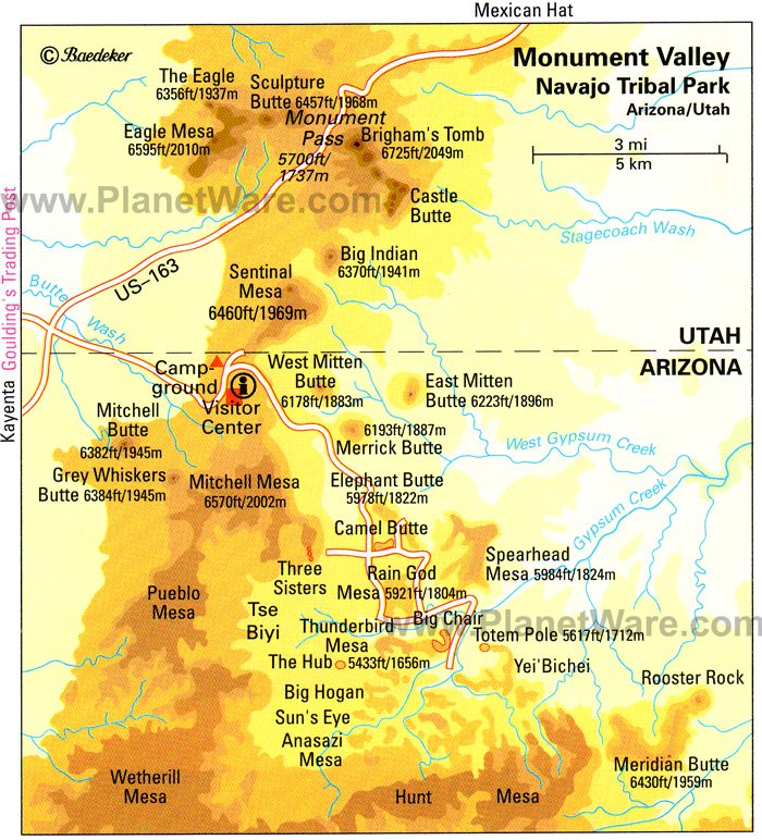
Figure 1: Map of Navajo Reservation: PlanetWare (2011)
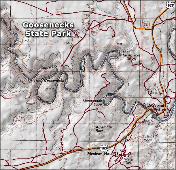
Figure 2: Map of Gooseneck State Park: VNizzle (N.D.)
Description of Locations
The first place we visited was Monument Valley (Figure 1; Figure 3). This is located beside the state line of Arizona and Utah on the Colorado Plateau and has an elevation of 5,564 feet above sea level. The area is characterised by several sandstone buttes, mesas and plateaus that are between 400 and 1000 feet in height (Navajo Nation Parks and recreation, 2011).

Figure 3: View from Visitor Centre: Monument Valley (Personal Photo)
Figure 4 shows John Waynes cabin at Gouldings Lodge. This area offers tourists the opportunity to experience a film set for a Western and to explore some of John Waynes equipment used within his films. Adding to this, there is a memorial for John Wayne outside of the cabin.

Figure 4: Ash entering John Wayne's Cabin (Personal Photo)
Figure 2 represents the last place visited, Gooseneck State Park, located 4 miles off Utah highway. Gooseneck is characterised by a meander in the San Juan River. It offers outstanding sights of natural processes that have occurred. The river can be seen to have cut 1000 feet deep into the Pennsylvanian Hermosa Formation (Utah.com,2011), that was laid down between 286 and 320mya (McGraw, N.D).

Figure 5: View of Gooseneck State Park, provides fantastic scenery for tourists visiting the park (Personal Photo).
Tourism

Figure 6: The directors chair is one of many features at Golding's Lodge of the western movie history
In 1958 the Navajo reservation government consulted dying residents about making a park at Monument Valley (Figure 1). Some residents were not in favour of the plans, however many residents were extremely pleased with the idea due to the number of positive impacts, such as increase in employment due to the surge of tourism demand. With the park now built the original visitor centre opened in 1960 and because of this the area was supplied with electricity and water hauled in by truck to fill a storage tank. Adding to this, further facilities such as power lines, phone lines and fresh local water began to be spring up in the area. Today many residents support themselves by selling arts and crafts and provide many other services to tourists. Finally, Monument Valley is not a national park which gives tourists a more hands on experience of the attraction.
Another source of tourism is the western history of Golding’s lodge. Many films have been produced within the area making it extremely popular for tourists. There are a vast range of tourist facilities available, these include museum, restrooms, car parks (disabled parking), seating areas, a gift shop and John Wayne’s cabin which allows the tourist to experience what Westerns were like in great detail.
Finally, Gooseneck is a primary tourist attraction, which attracts many tourists every year. Facilities here include toilets, information boards, a picnic bench and spacious car parking which gives the tourist the essential facilities to enjoy the attraction more appropriately.
As the observation show, there are many more facilities at Monument Valley compared to Gooseneck (Figure 2). This might be because people are more aware of Monument Valley, resulting in a higher tourist demand and therefore more facilities. During our visit, it appeared that there were fewer tourists in the visitor centre than at other National Parks we had visited, such as the Grand Canyon.. This may explain why the number of tourist facilities was also lower than other National Parks we had visited so far.
Resource Management

Figure 7: Car park beside Golding's Lodge in a relatively unmanaged area despite tourist demand
The Diné people, the original settlers of Monument Valley used the land to sustain themselves as a population. They planted crops and used irrigated the land by using water trapped in a natural dam. The land however was poor for agriculture and larger areas were required for the Diné people to carry out effective subsistence farming. Since the mid 1800s, the Navajo have been the primary settlers on the land and reared livestock along with some crop farming. This continued until 1920 when the fossil fuels of oil, gas and coal were beginning to be extracted from the area and used as an economic resource. In 1942 and 1943, World War II caused a rise in demand in uranium, a source of which was known to be within the area. This resource, along with the extraction of fossil fuels, provided the local Navajo population with jobs and a ‘modest’ income. However, despite the extraction of uranium ending in the late 1960s, the workers still suffer from the waste from the uranium, some of whom used local dirt as mortar for their dwellings, without knowing it was contaminated.
In the current day, the area still holds economic benefits in mineral extraction; although an added benefit of tourism has further raised the financial gain from the area. The popularity of Monument Valley in westerns has sourced popularity of the area and the scenic views.
The area has had recent development in facilities to compensate for the number of tourists including a hotel named ‘The View Hotel’, visitor centre, bar and gift shop, all in one location. Although Monument Valley holds ‘value’ both economically and scientifically, the area is not listed as a national park. The reason is because it lies within the Navajo territory and , due to the Navajo’s lack of financial resources, the extent and number of which facilities are available does not match that of other national parks, such as the Grand Canyon.
In 1958 the Navajo reservation government consulted Diné residents about making a park at Monument Valley. Some residents were not in favour of the plans, however many residents were extremely pleased with the idea due to the number of positive impacts it brings to area, such as increase in employment due to the surge of tourism demand. With the park now built the original visitor centre opened in 1960 and because of this the area was supplied with electricity and water hauled in by truck to fill a storage tank. Adding to this, further facilities such as power lines, phone lines and fresh local water began to be spring up in the area. Today many residents support themselves by selling arts and crafts and provide many other services to tourists. Finally, Monument Valley is not a national park which gives tourists a more hands on experience of the attraction.
Another source of tourism is due to the western history of Golding’s lodge. Many films have been produced within the area making it extremely popular for tourists. There are a vast range of tourist facilities available, these include museum, restrooms, car parks (disabled parking), seating areas, a gift shop and John Wayne’s cabin which allows the tourist to experience what Westerns were like in great detail. Finally, Gooseneck is a primary tourist attraction, which attracts many tourists every year. Facilities here include toilets, information boards, a picnic bench and spacious car parking which gives the tourist the essential facilities to enjoy the attraction more appropriately. As the observation show, there are many more facilities at Monument Valley compared to Gooseneck. This might be because people are more aware of Monument Valley which results in a higher tourist demand and therefore more facilities.
Physical Geography

Figure 8: Image displaying the different layers shown at Goosnecks State Park (Personal Photo)
There are two main theories given for how the buttes at Monument Valley were formed, the geologist theories and the Navajo beliefs. The geological explanation for the landforms is that layers of sediment once covered this region with streams flowing from a mountain range, older than the Rockies, which deposited sediments which hardened into the silt stones and shales of the valley floor. Wind caused sand dunes to form on top of this material. The area then sank and sediments from water and wind buried the area. Later, tectonic uplift caused the area to rise in a broad dome. It is wind that has caused erosion forming the landforms at monument valley.
The Navajo beliefs differ. Navajos believe that the earths surface was formed by flood waters welled up from worlds below. Living beings who emerged through a giant reed used chipped cutting tools to cut trenches, draining away flood waters, revealing land. Navajo beliefs now say that the river beds of the Rio Grande and San Juan rivers were formed by these trenches.
Although there are different beliefs, it is understood that visitors are threatening the landforms and sacred places. Noise from engines is making rocks collapse and road construction and dust is also discouraging plant medicines.
Adding to this, Gooseneck National Park is the biggest entrench meander in the world. It is a fossilised meander that has not got the energy to cut a straighter channel. The area has been lifted by tectonic processes so evenly that the river slope has not increased enough to allow for the river to erode a straighter channel. The San Juan has eroded through many alternating layers of variant residences of rock including hard rock (Limestone) and soft rock (Mud). The upper most layer contains many alternating beds of limestone, shale and sandstone, each layer representing the different types of depositional environments the area was in through the visible geological history. Eventually the river will erode the rock and create ox bow lakes, however the predicted quantity of water flowing is thought to decrease due to global warming, effectively limiting considerable erosion to only occur in some storm events.
Personal Reflections
Our day has been interesting and valuable to our learning of the areas we have visited. Our experiences of the day have enhanced our knowledge and understanding of the issues relating to tourism, resource management and the physical geography of both Monument Valley and Gooseneck State Park. The field work has allowed us to learn about Monument Valley and Gooseneck in a different light, enabling us to better understand these environments on a variety of spatial and temporal scales. We think we have researched the attractions thoroughly and explained the three components accurately and effectively. Comparing to the other attractions Monument Valley is, at least to us, a marvel just like the Grand Canyon but in its own unique way. The added features of the westerns films only add to the sceptical and further add to the experience of the area. If we hadn’t had to do MIP work we probably would have enjoyed it even more than we did, but alas, it was not to be. Was still awesome though.

Figure 9: Group photo with Monument Valley as the backdrop
Reference List
McGraw (N.D.) Geological Timescale [online] Available from: http://accessscience.com/geologicTimeScale.aspx [Accessed: 17/05/11]
PlanetWare (2011) Monument Valley Navajo Tribal Park Map [online] Available from: www.planetware.com [Accessed: 17/05/11].
VNizzle (N.D.) Goosenecks State Park [online] Available from: www.vnizzle.com. [Accessed: 17/05/11].
Navajo Nation Parks (2011). Monument Valley Navajo Tribal Park. [online] Available from: www.navajonationparks.org. [Accessed: 17/05/2011].
Utah.com (2011) Goosenecks State Park [online] Available from: www.utah.com [Accessed: 17/05/2011].
No comments:
Post a Comment